
Susmita Chaudhary
I'm passionate Designer
About
Geomatics Engineer with experience in GIS analysis, WebGIS development, remote sensing, and spatial data management contributing to urban planning, disaster preparedness, and geospatial education for sustainable urban development, data-driven decision-making, and community impact.

Geomatics Engineer | WebGIS Developer | GIS Analyst.
I am a Geomatics Engineering graduate from Kathmandu University. My field of expertise is WebGIS Development and GIS analysis.
- Website: www.susmitachaudhary.com.np
- Phone: +977-9822818666
- City: Kathmandu, Nepal
- Degree: Bachelor
- Email: susmitachaudhari13@gmail.com
- Freelance: Available
Professionally, I am a geomatics engineer expertising in the field of GIS and Remote Sensing. I am dedicated towards python and django development and also in GeoAi. I am dedicated to professional surveying and handling the advanced surveying equipments. I have a strong work ethic and customer service and satisfaction record. I am a multitasker, capable of carrying simultaneous surveying and gis analysis and repair project to completion with full accuracy and efficiency.
Projects
Hours Of Support
Hard Worker
Skills
Resume
Summary
Susmita Chaudhary
I completed my Bachelor's degree in Geomatics Engineering from Kathmandu University in 2024. Since then, I have gained over two years of professional experience across multiple sectors and organizations, specializing in geospatial analysis and data-driven solutions. I am passionate about integrating geospatial technologies to develop sustainable solutions for urban planning and disaster risk reduction.
- Ghorahi,Dang,Nepal
- +977-9822818666
- susmitachaudhari13@gmail.com
Education
Bachelor's in Geomatics Engineering
2019 - 2024
Kathmandu University, Dhulikhel, Nepal
I hold a Bachelor's degree in Geomatics Engineering from Kathmandu University, Nepal (2019–2024), graduating with a GPA of 3.73. My thesis focused on assessing land degradation in Khotang District using GIS and remote sensing. During my studies, I developed expertise in GIS, remote sensing, surveying, photogrammetry, geodesy, spatial databases, programming (Python, MATLAB, C++), WebGIS, and land administration.
Higher Secondary Education
2017 - 2019
Siddhartha Academy, Ghorahi, Dang.
I completed my Higher Secondary Education (+2) in the Science faculty at Siddhartha Academy, Ghorahi, Dang. The program focused on Physics, Chemistry, Biology, and Mathematics, providing a solid foundation in scientific principles, analytical thinking, and problem-solving skills that prepared me for advanced studies in Geomatics Engineering.
Professional Experience
Assistant GIS Consultant
Sep 2025 - Present
Community Self Reliance Center, Kathmandu, Nepal
- Digitizing spatial features and building project geodatabases, including settlements, infrastructure, and hazard-related layers, while updating and validating OpenStreetMap (OSM) data for local government mapping and planning.
- Conducting flood risk analysis and Participatory GIS in vulnerable municipalities, creating community-centered map visualizations and analytics to enhance risk assessment, preparedness, and communication with local stakeholders.
GIS Engineer
Jan 2025 - June 2025
Kathmandu Metropolitan City, Kathmandu, Nepal
- Performed spatial analysis, flood mapping, and automated feature extraction using ML on UAV and satellite imagery; designed and implemented a WebGIS platform for the Urban Management Department, integrating spatial layers such as roads, rivers, land use, and public Volunteer Work & Training.
- Coordinated road inventory surveys, supported a mobile app for real-time field data collection, led scientific road naming, developed a digital road database with house numbering, and ensured data quality, metadata documentation, and integration into KMC’s centralized GIS platform.
WebGIS Developer
March 2024 - Jan 2025
NAXA, GeoICT company, Kathmandu, Nepal
- Developed and maintained backend systems for the Digital Metric Addressing System (D-MAPS), designing spatial databases with PostGIS and building APIs for geospatial data Volunteer Work & Training.
- Integrated road and building datasets into a functional WebGIS platform, supporting address logic development and ensuring data accuracy and system performance.
GIS Instructor
March 2025 - Nov 2025
Gyanhub, Kathmandu, Nepal
- Delivered GIS training as a part-time instructor, teaching spatial data analysis, cartography, coordinate systems, and GPS integration using ArcGIS, QGIS, and Google Earth, while mentoring over 100+ students, simplifying complex concepts, and supporting hands-on project workflows and map interpretation.
Portfolio
This portfolio presents selected works in GIS, Remote Sensing, WebGIS, and Participatory GIS & Capacity Building. Some project are not shown due to confidentiality obligations.
- All
- GIS & Remote Sensing
- WebGIS
- Participatory GIS & Capacity Building
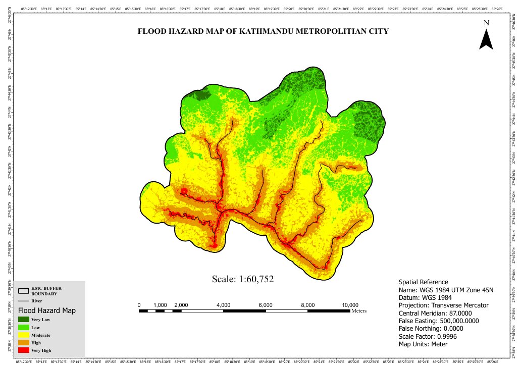
Flood Analysis of Kathmandu Metropolitan City
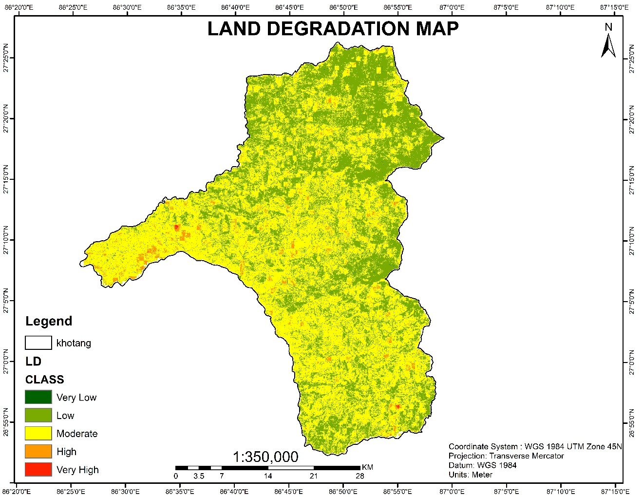
Land Degradation Map of Khotang District

Land Use & Land Cover Map of Dang

Lentil Production in Karnali
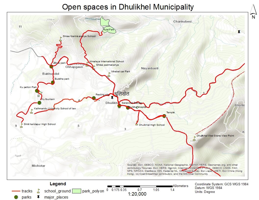
Open Space Map of Dhulikhel
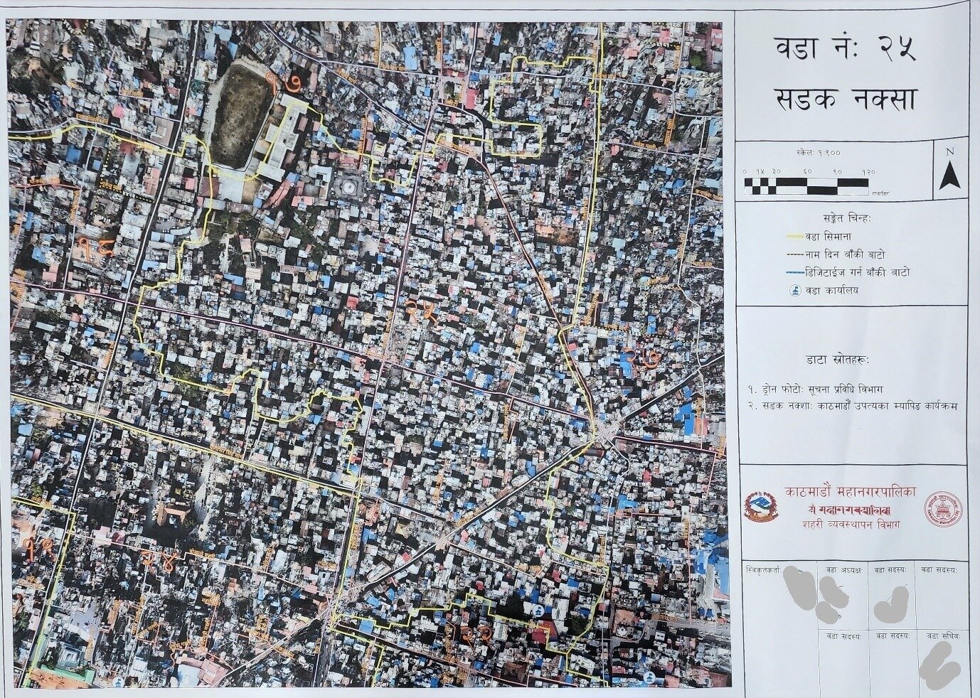
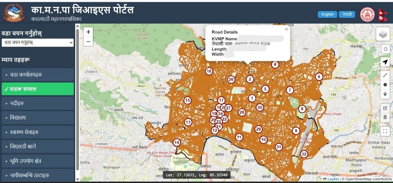
Road Map of Kathmandu Metropolitan City-28
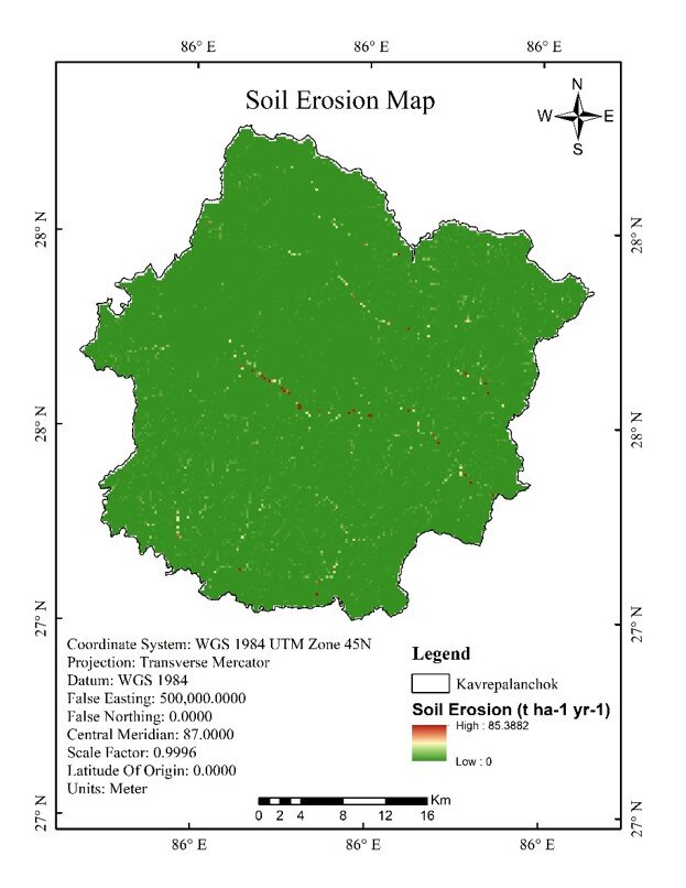
Soil Erosion (RUSLE) – Kavre District
Urban Management Department Geoportal
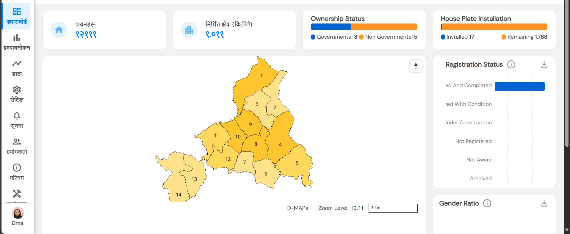
NAXA D-MAPS Portal
Connecting Space to Villages – Capacity Building


PGIS Activity for Scientific Road Naming
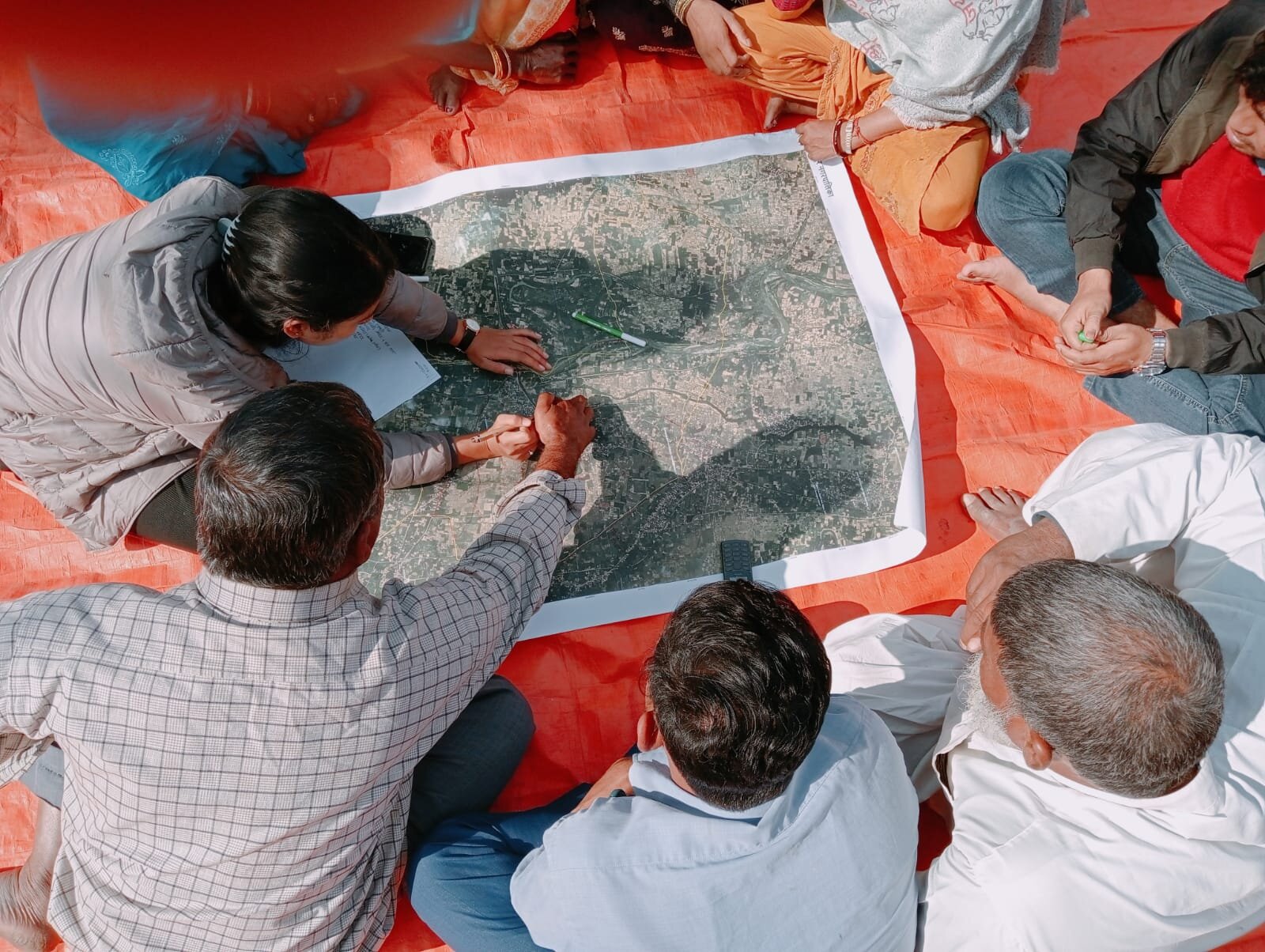
PGIS for Flood Risk Reduction
Volunteer Work & Training
Volunteer Works
Location: Dhulikhel, Kavrepalanchok, Nepal | Website | Email: contact@ewb.org.np
Duration: 07/02/2024 – 05/02/2025
- Played a key role in establishing the Kathmandu University chapter of Engineers Without Borders
- Contributed to planning and executing community-focused engineering initiatives
- Promoted sustainable development and student engagement through technical outreach and awareness programs
- Collaborated with peers and advisors to design solutions addressing real-world social and environmental challenges
Location: Dhulikhel, Kavrepalanchok, Nepal
Duration: 14/03/2021 – 10/03/2022
- Assisted in organizing cultural and academic events promoting the identity and inclusion of students from Nepal’s mid-western region
- Maintained communication between executive members and general students
- Contributed to documentation, meeting coordination, and event planning logistics
- Supported initiatives focused on student welfare, leadership, and regional representation
Location: Tachikhel Street, Lalitpur, Nepal | Website | Email: info@ran.org.np
Duration: 03/07/2021 – 04/01/2022
- Trained schoolteachers in Earth Observation (EO) and Geospatial Information Technology (GIT)
- Contributed to integrating EO/GIT into local curriculum development
- Promoted geospatial literacy in classrooms across rural Nepal
Location: Tachikhel Street, Lalitpur, Nepal | Website | Email: info@ran.org.np
Duration: 03/07/2021 – 04/01/2022
- Coordinated oxygen supply logistics and emergency response efforts in Province 5 during the COVID-19 crisis
- Led a regional volunteer team to support critical care resource distribution
- Volunteered in FOSS4G Asia 2021 and FIG 2024 as part of the Design/Social Media Team
- Participated in Mapping Chepang Community initiatives
Duration: 2022, 2023
- Instructed students in map literacy and GIS fundamentals
- Provided hands-on guidance for spatial analysis and cartography exercises
Trainings Attended
Duration: 01/01/2022 – 30/06/2022 | Location: Online (Philippines) | Website
- Women’s leadership in geospatial fields
- Humanitarian OpenStreetMap (HOT) mapping
- Open mapping tools (iD Editor, JOSM)
- Community engagement and digital advocacy
Duration: 09/07/2024 – 12/07/2024 | Location: Khumaltar, Lalitpur, Nepal | Website
- GIS and Remote Sensing fundamentals
- Earth Observation applications in the Hindu Kush Himalaya (HKH) region
- Use of SERVIR-HKH services for land cover analysis and disaster preparedness
- Capacity building for women in geospatial sciences
Duration: 10/08/2024 – 17/08/2024 | Location: Tachikhel Street, Lalitpur, Nepal | Website
- Foundational UAV operation and safety
- Flight planning and execution
- Aerial data collection using drones
- Basics of photogrammetry
- Geospatial mapping applications using drone imagery
Duration: 14/07/2023 – 21/07/2023 | Location: Dhulikhel, Kavrepalanchok, Nepal | Website
- Introduction to Google Earth Engine (GEE)
- Satellite image processing and visualization
- Land cover classification using remote sensing
- Time-series analysis and change detection
- GEE coding environment and scripting in JavaScript
Contact
Current Address
Kathmandu, Nepal
Phone
+977-9822818666
Email me
susmitachaudhari13@gmail.com